Why Do Currents Flow?
Currents exist at all depths in the ocean; in some regions, two or more currents flow in different directions at different depths. Although the current system is complex, ocean currents are driven by two forces: the Sun and the rotation of the Earth.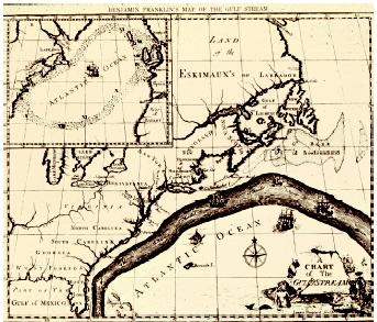
The Gulf Stream is one of the strong ocean currents that carries
warm water from the tropics to the higher latitudes. In contrast to
the nontechnological methods used to produce early maps of the Gulf
Stream, today's remote sensing technology on satellites
allows scientists to delineate the current's features and
follow changes in its position. (See "Geospatial
Technologies" for a satellite image of the Gulf Stream.)
Ekman's Theory.
The first reasonable theory of how the wind affects surface currents was derived by Swedish oceanographer and mathematician Valfrid Ekman in 1890. Ekman considered an infinitely wide and deep ocean of constant density, divided into an infinite number of horizontal layers. The top layer is affected by the wind and by friction with the layer below it. The second layer is also affected by friction at top and bottom, and so on. The Coriolis force also affects the layers because they are moving.Balancing the friction and the Coriolis force led Ekman to conclude that the resulting currents decreased exponentially with depth, that the surface current moved at a 45-degree angle to the wind direction, and that deviations from the surface wind direction increased with depth, forming a spiral (to become known as the Ekman spiral). Adding the movement at all depths gives a mean (average) current that moves at right angles to the wind direction, to the right in the Northern Hemisphere, and to the left in the Southern Hemisphere. Such Ekman spirals are rare, but have been observed in the ocean.
Because the oceans are neither infinitely wide nor of constant density, as Ekman assumed, complications arise at the boundaries, where water tends to "pile up." The surface of the ocean is then no longer flat, but has a slope, which sets up a horizontal pressure gradient. The combination of the Coriolis force and the horizontal pressure gradient produces a current that flows at right angles to the pressure gradient; when the two forces are equal, this is known as a geostrophic current. All major current systems in the ocean can essentially be considered geostrophic
Patterns of Surface Currents
The general pattern of surface currents in the ocean is shown in Figure 1. This shows a series of quasi-circular gyres, or large eddies, in each ocean basin . The gyres tend to be biased towards the western side of the basin, where strong, narrow flows are found in the Gulf Stream, Kuroshio, Agulhas, Brazil, and East Australian Currents, which flow at speeds up to 2.5 meters per second (6 miles per hour). The volumes involved in these western boundary currents are large; the Agulhas, for instance, carries about 80 Sverdrups of water in the upper 1,000 meters (about 0.6 mile). Current speeds away from the western boundaries of the gyres are generally much lower, and currents on the eastern boundaries of ocean basins are much wider.The gyres rotate clockwise in the Northern Hemisphere and counterclockwise in the Southern Hemisphere because of the Coriolis force; in this they follow the prevailing wind patterns. The northern Indian Ocean is an exception because of the intense atmospheric monsoon system that changes its direction twice a year, but an intense circular current system, the Great Whirl, develops off Somalia during the southwest (summer) monsoon.
The gyres in both ocean and atmosphere help to transport heat away from the equator towards the poles (the Gulf Stream keeps northern Europe
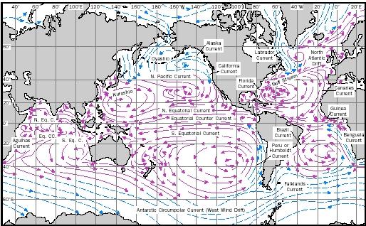
Figure 1. This map shows the global surface current system under
average conditions for winter months in the Northern Hemisphere.
Warm currents are shown as solid red arrows, and cold currents as
dashed blue arrows.
Deep Currents
Currents in the deep ocean exist because of changes in the density of sea water occurring at the surface. These density changes give rise to specific water masses, which have well-defined temperature and salinity characteristics, and which can be traced for long distances in the ocean.When sea water freezes, much of the salt that it contains is frozen out, so that a layer of cold brine forms at the ocean surface. Being denser than the water below it, the brine sinks, entraining water as it does so, until it reaches a level where it has the same density as the surrounding sea water. This process takes place in several regions of the world's oceans, the most important being in the Greenland, Norwegian, and Labrador Seas in the Northern Hemisphere, and close to the Antarctic continent in the Weddell and Ross Seas in the south.
It is the dense waters formed by this process that set up the deep ocean current patterns. Water formed in the Weddell and Ross Seas spreads eastwards and northwards around Antarctica under the influence of the Coriolis force. As is the case with surface waters, most of the flow is concentrated on the western sides of ocean basins, but in this case movement is towards the north. In the South Atlantic Ocean, for instance, bottom water from the Weddell Sea can be identified flowing through the Argentine and Brazil Basins below 4,000 meters (2.5 miles) in depth; it eventually crosses the equator into the North Atlantic off the coast of Brazil. Similar effects are found in both the South Indian and South Pacific oceans, with the bottom waters being forced to follow the bottom topography .